Hiking the Navajo Loop and Queen’s Garden Trails in Bryce Canyon
Disclosure: This blog is reader-supported, and some posts contain affiliate links. If you make a booking, I may earn a small commission—at no extra cost to you. Thank you for keeping me writing and doing what I love!
With over 65 miles of hiking trails, Bryce Canyon National Park is an awesome destination ideal for hiking. The Navajo Loop and Queen’s Garden trails are two of the most popular trails to hike for a one-day trip to Bryce Canyon.
Most people actually combine the Queen’s Garden 0.9-mile trail with a portion of the 1.4-mile Navajo Loop trail to get a good overview of Bryce Canyon’s geological formations.
Navigating Bryce Canyon’s vast trail network isn’t hard, but it can be confusing at first. I did a lot of research before our trip and it helped us plan the best hiking route within our allotted time. We arrived at Bryce Canyon in the morning between 8-9 AM and spent the better part of 3 hours hiking the Navajo Loop and Queen’s Garden trails. We also got to see a handful of the panoramic viewpoints along the 18-mile scenic drive that skirts the canyon rim.
If you’re looking for the perfect adventure in Bryce Canyon, search no more! Read our full itinerary below.
Here is everything you need to know about hiking the Navajo Loop and Queen’s Garden trails in Bryce Canyon National Park!
Save on national park entry fees — purchase your America The Beautiful park pass (and get entry into all US national parks for one whole year!).

How to Hike the Navajo Loop and Queen’s Garden Trails

When you first drive into Bryce Canyon, make a short pit stop at the Bryce Canyon Visitor’s Center to check for trail updates, use the restroom, or pick up a cute souvenir (I couldn’t resist the vintage illustrated postcards!).
To make the most of your hike around the Navajo Loop and Queen’s Garden trails, you’ll want to drive and park your car at Sunset Point. From here, you’ll walk to Sunrise Point where the Queen’s Garden Trail begins. Don’t worry about seeing Sunset Point just yet, as your return hiking route will end back here. To get to Sunrise Point, leave the parking lot and walk along the paved Rim Trail that overlooks the incredible Bryce Amphitheatre housing all the crimson hoodoos.

The Queen’s Garden Trail descends into the valley of the hoodoos from Sunrise Point.
After hiking 0.9 miles and a short break at the end of Queen’s Garden, you’ll hang a right toward the Navajo Loop Trail. You’ll walk approximately another 0.7 miles until you reach where the Navajo Loop begins and splits into two.
The Navajo Loop Trail consists of two trails – Wall Street or Twin Bridges. You have to choose one to make your return trip back to Sunset Point where you left your car. Each has 500-ft inclines and is 0.7 miles in length.
Make sure to buy an America The Beautiful park pass if you plan on visiting several national parks! Passes last for one calendar year and save you soo much money. It pays for itself if you visit just 2-3 National Parks that year!
Both trails have unique zig-zagging trails, but for a little more exciting adventure, take Wall Street. Note: in winter, only Twin Bridges is open.
The Wall Street Trail features Bryce’s only slot canyon, two 400-year-old Douglas Firs, and the final switchback trail that’s total Indiana Jones vibes.
At the top, turn around and take a look down at the maze you just climbed! You’re now just under Sunset Point. Take a quick left to peer through a window into the canyon slopes next to Wall Street.
Turn right to head back up to Sunset Point while getting a brief overlook of Thor’s Hammer at the end of the Twin Bridges Trail.


Trail Lengths
- Sunset to Sunrise Points – 0.5 miles walking via the Rim Trail
- Queen’s Garden Trail – 0.9 miles one-way downhill into the hoodoos
- Distance from Queen’s Garden to join the Navajo Loop Trail – 0.7 miles walking on the valley floor
- Navajo Loop – 1.4-mile loop consisting of Wall Street and Twin Bridges Trails (0.7 miles each)
Total hiking distance combining the Navajo Loop and Queen’s Garden Trails = ~2.9 miles, 2-3 hours.
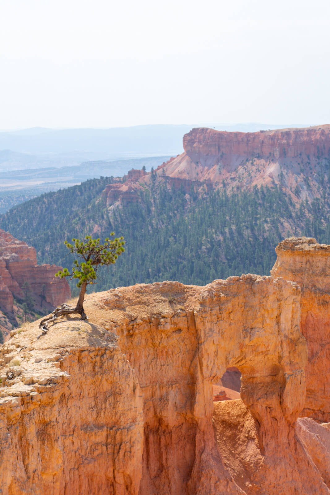
Sunset Point to Sunrise Point
Sunset Point and Sunrise Point are two viewpoints on opposite sides of the Bryce Amphitheatre. They are the main viewpoints from which you’ll see the best of Bryce’s crimson and creamsicle hoodoos, windows, and fins.
The distance between Sunset and Sunrise Point is only 0.5 miles, give or take. The paved walking path is extremely scenic, wheelchair accessible and pet-friendly.
From what I’ve seen, dogs are allowed on leash on the paved Rim Trail but not down in the valley.
There are scenic photo spots to stop and capture on your walk to Sunrise Point in addition to a few resting benches. Be sure to watch your step if you are near the edge though, as there are no barriers. Keep small children close by.
Once at Sunrise Point, you’ll see the trailhead for Queen’s Garden.
Queen’s Garden Trail

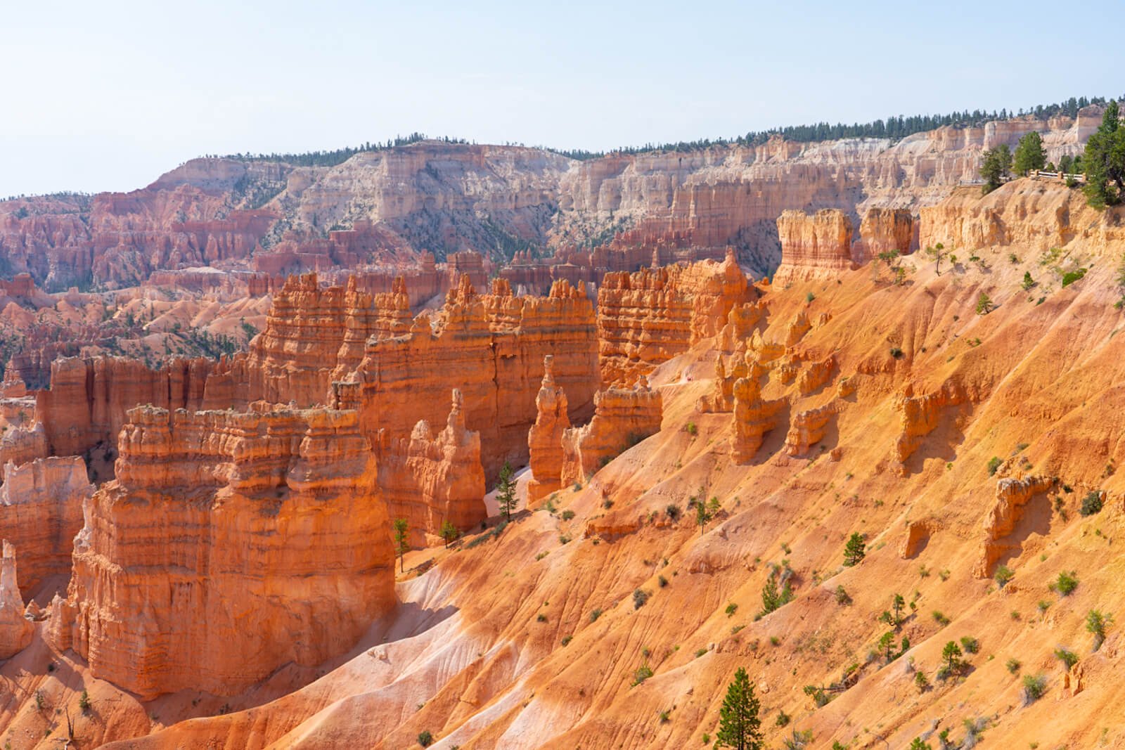
The beginning of Queen’s Garden Trail takes you down a steady slope on a dirt path. From here, you can see the trail winding its way down into the valley. As you go, notice how the colors of the rock change from light beige to saturated browns and oranges.
Take note of the geological formations called windows and fins that will eventually create more hoodoos.
Hoodoos are the pinnacles you see in Bryce Canyon, that are separated from each other.
Windows are what they sound like – hoodoos that connect to one another forming little “windows”. Fins are thin canyon walls, that with time and weather erosion, will turn into stand-alone hoodoo spires.
The Queen’s Garden Trail continues to descend about 350 ft into the valley until you reach Queen’s Garden with the iconic Queen Victoria hoodoo. They call it Queen Victoria because the spire literally is shaped like the Queen.


The Queen’s Garden trail is an out-and-back trail, meaning to get back up to the plateau you’ll need to choose either to hike up the 0.9 miles you just came or continue along the valley floor and exit out via one of the trails (Wall Street or Twin Bridges) on the Navajo Loop Trail.
From Queen Victoria’s garden, it’s 1.4 miles back to Sunset Point via Navajo Loop. That means you can either choose 0.9 miles back the same way (QG) or go 1.4 miles via a new and extremely scenic route (toward Navajo and then via Wall Street or Twin Bridges).
You can also access the Peek-A-Boo Trail via Queen’s Garden Trail, but this hike is a little long for just a day trip to Bryce. Maybe with a few days, it would be doable. It also is one of the few horse-friendly trails in Bryce.
Navajo Loop Trail


After a visit to Queen Victoria, you’ll turn around and swing a right down toward Navajo Loop. Notice that this path isn’t a part of the Navajo Loop itself.
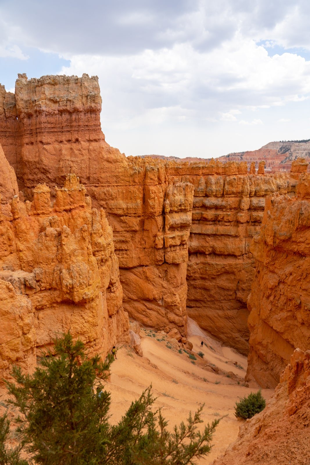
There’s still a 0.7-mile walk on the valley floor before you reach the fork where Navajo Loop begins and can choose either to complete the roundtrip hike via Wall Street (left) or Twin Bridges (right).
The Navajo Loop is 1.4 miles with each trail being approximately 0.7 miles in length. Also, both Wall Street and Twin Bridges feature roughly 550-ft inclines. Basically, there’s no escaping an uphill climb once you’re already down in the valley. Even if you turn around and hike back up Queen’s Garden Trail, it will still be a 450-500 ft ascent.
Wall Street

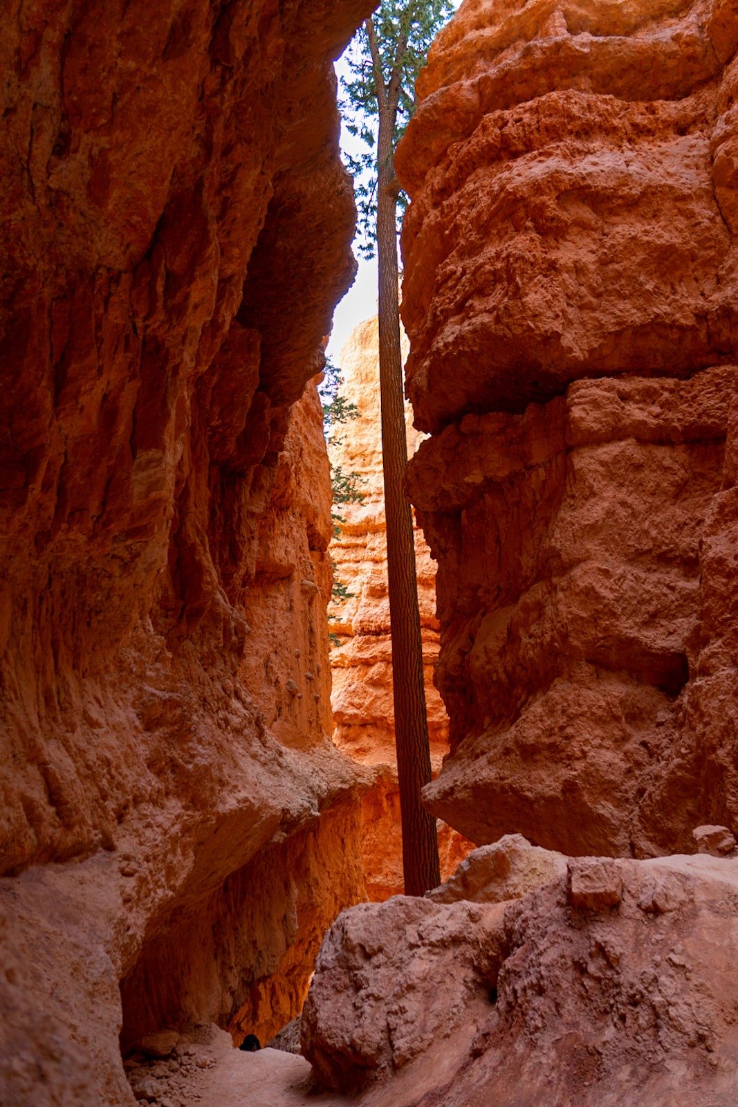

I personally can vouch for the epicness of the Wall Street portion of the Navajo Loop. Not only do you get to see Bryce’s only slot canyon, but you also get to see the two iconic 400-year-old Douglas Fir trees towering between narrow canyon walls.
The final climb is a dizzying succession of zig-zagging switchbacks.
As I said earlier, it gives off extreme Indiana Jones vibes. The view from below is just as stunning as it is from above. You won’t regret ending your hiking adventures in Bryce Canyon with Wall Street!
If you’re hiking during the wintertime, Wall Street will be closed and you’ll have to end your Navajo Loop and Queen’s Garden combo hike with Twin Bridges.
Alternative: Twin Bridges

From what I’ve seen and heard, Twin Bridges is equally as exciting as challenging as Wall Street.
On this route, you’ll pass under two arches, “bridges” and scurry up a winding path of switchbacks.
The switchbacks at Twin Bridges feature more open space, whereas in Wall Street you’re really surrounded by towering canyon walls and craggy spires.
The main attraction of the Twin Bridges Trail is the chance to see the famous Thor’s Hammer hoodoo. It is supposed to look like Thor’s Hammer, but honestly, it’s not that impressive after seeing all the other unique hoodoo formations in the valley.
Besides, you can see Thor’s Hammer once you come back up from Wall Street Trail or from the viewing deck at Sunset Point. For us, that was good enough just to snap a pic and say that we saw it.


Can you spot Thor’s Hammer? (Hint: Tallest spire from the lower right with a grey flat top)
Last Tips for Hiking the Navajo Loop and Queen’s Garden Trails in Bryce Canyon
National Park Pass — Entry into Bryce Canyon National Park costs $35 per vehicle. If you plan to visit other national parks then consider buying an America The Beautiful pass to save money.
Clothing — Wear good hiking boots as the dirt/unpaved hiking trails can be slippery. Wear breathable clothes. Bring a hat and sunscreen as most of the trail is exposed to direct sun.
Leave No Trace — Follow the Leave No Trace principles. Pack out what you pack in, don’t wander off unmarked trails, and leave all plants, rocks, and animals as they are.
Weather — Prepare for temperamental weather at Bryce. It can go from hot and sunny to cold and rainy in minutes! Don’t hike in open areas or stay near trees during thunderstorms.
Wildlife — Wildlife, like rattlesnakes and mountain lions, call Bryce Canyon home. Be mindful and respectful of their space in the rare chance you spot one.
Safety — Bring plenty of drinking water and don’t over-exert yourself when you need to rest. Heat exhaustion kills. Remember Bryce also sits at 8,000 ft and the high elevation can pose a risk if you have heart/respiratory conditions.
Last but not least, have fun hiking the Navajo Loop and Queen’s Garden Trails!
I hope this information was helpful for you to plan your trip. I truly believe Bryce Canyon National Park is best explored with your own two feet. I already look forward to the day when we can go back and hike even more trails!
Check out my guides to Zion National Park and hiking the Narrows in Zion for more Utah travel inspiration!
Save this hiking guide to Bryce Canyon to Pinterest!


THANK YOU SO MUCH for helping us plan our Bryce trip!!! This was incredibly helpful! Can’t wait to get there 🙂
Thanks so much for letting me know, Maddy! So exciting! Bryce is the B E S T. So beautiful – enjoy! x