Hiking Guide to Mount Brandaris on Bonaire Island
Disclosure: This blog is reader-supported, and some posts contain affiliate links. If you make a booking, I may earn a small commission—at no extra cost to you. Thank you for keeping me writing and doing what I love!
If you have the chance to fly into Bonaire during the day, you’ll notice the island is extremely flat apart from a few rolling hills in the northwest (and the curious ‘white mountains’ of salt in the south).
It’s here on the northwest side of the island, inside Washington-Slagbaai National Park, where you’ll find Mount Brandaris—the island’s tallest peak, reaching skyward 241 m or 791 ft.

While hiking isn’t the reason why tourists flock to Bonaire, the hike to the top of Brandaris is definitely worth adding to your itinerary. It is arguably one of the top things to do in Bonaire (especially for non-divers).
Brandaris is not that tall, but the hike offers a challenge nonetheless. It definitely is a hill more than a mountain, per se, but you won’t get better views of the island and the surrounding national park and Caribbean sea than atop its rocky summit.
Below, I detail everything you need to know about climbing to the top of Brandaris on Bonaire Island!
Hiking Guide to Mount Brandaris
🥾 Time: About one hour (up) and 45 minutes (down).
☀️ Trailhead: Take the “short route” inside Washington-Slagbaai National Park to reach the Subí Brandaris Trailhead.
🛻 Drive Time: It takes around 30-40 minutes to reach the trailhead, so it’s best to enter the park at 8 am when it opens. A 4×4 or high-clearance truck is recommended.
🎟 Nature Fee: Entry into the national park costs $45 (if you’ve pre-purchased the diving/park access STINAPA nature tag, your entry is already covered).
🎒 Pack: One gallon of water per person, sunscreen, hat, and sunglasses! There is little to no shade on the trail.
🌵 Wear: Close-toed shoes since the trail can be prickly with cacti!

Where Is Mount Brandaris?
Mount Brandaris is one of the many hills and geological formations you’ll find inside the Washington Slagbaai National Park on the northwestern part of Bonaire Island.
Most of the island is flat and desert-like, but inside the national park, you’ll be surrounded by freshwater lakes, Kadushi cacti, beaches, and rolling hills. It’s hard to comprehend just how big the national park is until you reach the summit of Brandaris.
Did you know? Washington Slagbaai National Park actually covers about 20% of Bonaire Island! 🌵
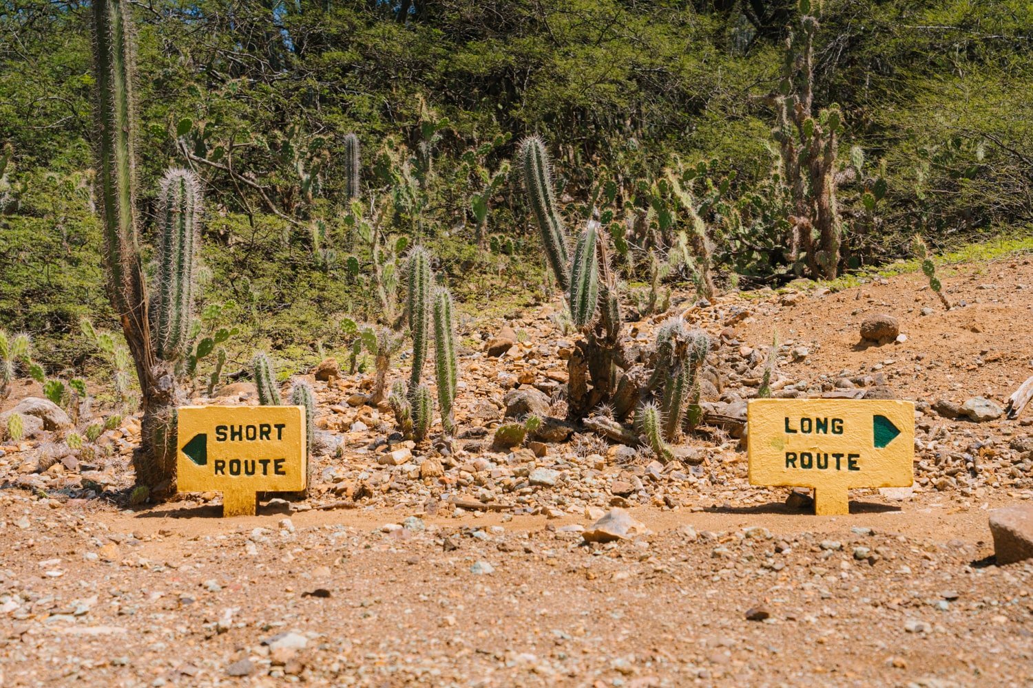
To climb Brandaris, you’ll need to drive through the national park via the short route. You cannot backtrack on the route you take as it is one-way, so if you choose to hike Brandaris, know that you’ll have to come back on a separate day to drive the long route inside the park.
Brandaris Trail Details
Getting to the Trailhead
As a reminder, the park hours are 8 am to 5 pm, so you should plan to be ready at the entrance around 8 am to take advantage of the cooler mornings.
There is little to no shade on the trail, especially as you have to scramble to reach the rocky summit so starting earlier rather than later is wise.
After you show your STINAPA nature tag and ID to enter the park, the drive to reach the Subí Brandaris Trailhead takes about 30-45 minutes.

If you haven’t reached a sign that says “Subí Brandaris” then you haven’t reached it yet. Do not turn off on any of the unmarked dirt roads.
Once you see the trailhead sign, you can park your SUV/truck on the lefthand side of the road. Make sure to take all valuables with you or leave them at your hotel.
The Shady Start of the Trail
The path begins out very easy, with nothing but some rocks and fallen cactus pieces to step over. If you hear rustling in the cacti and bushes, don’t fret—it’s just lizards! We saw hundreds of lizards big and small (including iguanas) on this trail.
This part of the trail is semi-shaded, but you should still consider wearing a hat and sunscreen and covering your shoulders to protect yourself from the sun.

Remember to Close the (Goat) Gate!
After about 20-25 minutes of walking, you’ll reach a gate that is meant to keep goats safely inside. Don’t forget to close it behind you on your way up and down.
From here, the trail begins to ascend quite gradually until the wind-bent trees clear and you are on your way to scrambling up the rocks ahead.
The Scramble to the Summit
The last 30 minutes of the hike are all about scrambling and climbing. While the summit doesn’t seem so far away, there are a lot of boulders between you and it that you need to navigate slowly.
It’s clear that the locals can speed up and down this trail, but if you aren’t sure-footed you should indeed take your time.
The wind also picks up heavily once you reach the clearing, so hold on to your hats (mine almost blew away!).
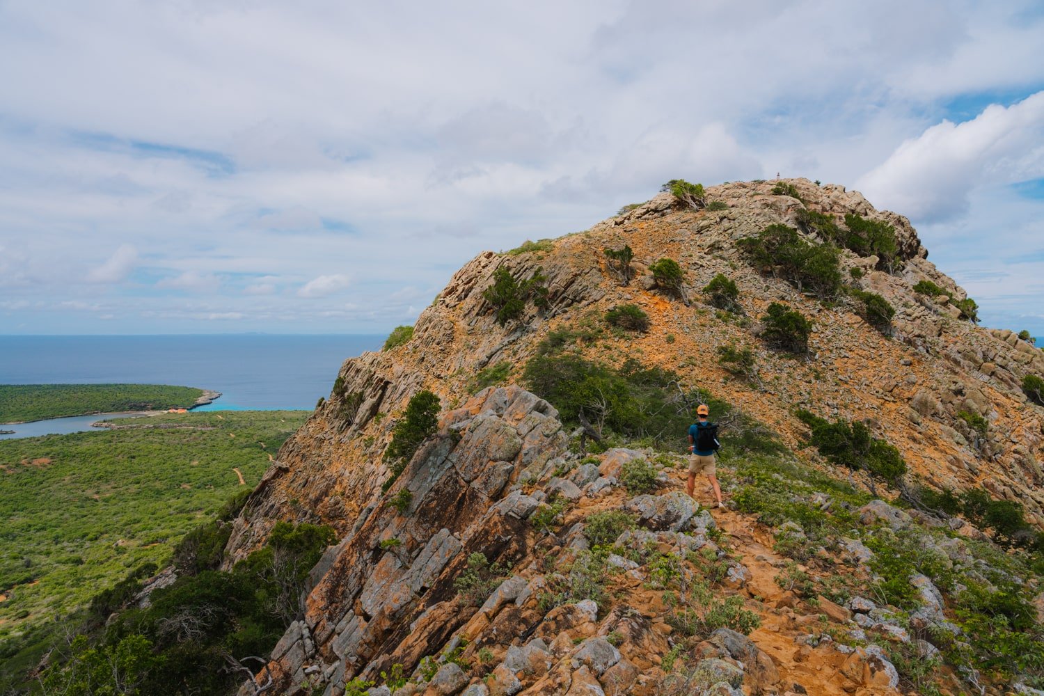

The panoramic view of the island starts taking shape on your way up, but don’t linger too long as the view only gets better from the top!
Most importantly, don’t forget to take breaks whenever you see shade and drink plenty of water to stay hydrated.
While the hike isn’t difficult, it may take more time than estimated. The sign at the trailhead suggests around 30-40 minutes to reach the summit, but we clocked about one hour (and we’re not slow hikers).
Reaching the Top of Mt Brandaris
Finally, once you reach the tip-top of the rocks there will be a little concrete structure indicating you’ve reached the summit. You made it!

From atop this point, you can see the entire island of Bonaire and even the island of Curaçao in the distance (and possibly Venezuela).
While the view around you is spectacular, don’t forget to look down to see a metal badge nailed into the rocks near your feet. It reads, “Inter-American Geodetic Survey, Brandaris” with the year 1953. After researching online, I discovered that IAGS was a Cold-War project launched by the U.S. Army to map uncharted and undocumented regions across Latin America. Interesting!


Last Tips for Hiking Brandaris on Bonaire
Even though the short route in the Washington Slagbaai National Park isn’t the most scenic or popular, it’s the one that leads to the Brandaris hike.
While you won’t be able to drive back and take the long route, you’ll still get the chance to snorkel at Wayaka and go cliff jumping at Boka Slagbaai.
🌵 Read more things to do inside Washington Slagbaai National Park
Before you go, remember:
- 💧 Bring plenty of water since there are no facilities inside Washington-Slagbaai Park
- 🌿 Always pack out what you pack in!
- 🥾 Leave No Trace
I hope this quick trail guide helps you plan your visit! If I’ve missed anything, please leave a comment or question below and I’ll get back to you!
PIT IT FOR LATER

